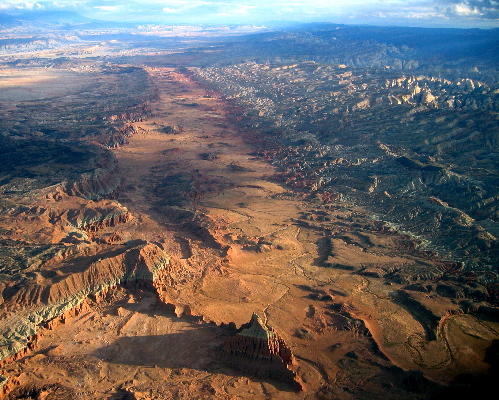
Taken from a Cessna late in the evening (as you may have guessed from the shadows). In the bottom left corner you can see the road to the desert overlook. We took this picture when my Dad and I flew down to scout out hiking spots for the scouts. I was trying to help them visualize topographic maps. I figured a picture would be helpful. I think it was but the flying was great either way.
How to get there (on the ground) Get off I-80 at the road to Hanksville. Go south to Hanksville. Turn west toward Fruita. Drive into Fruita and check road conditions at the NPS visitor center. Drive back to the west and turn north onto the Cathedral Valley road. Ford the Freemont river in you vehicle if it looks safe to do so. Drive to the South Desert Overlook. Get out of your car and look at the overlook. Marvel that you can be so close to your car yet feel so isolated.
How to get there (in the air) fly down to Fruita, if you go on a Saturday morning, stop by the Richfield airport for fuel and sourdough pancakes on your way to Fruita. From Fruita, fly around to the south, north and east for best views. Avoid flying into scenery while viewing scenery. Go late in the evening in marginal VFR conditions that clear up right as you hit the waterpocket fold for best results.
No comments:
Post a Comment